This is an archived version of this site. For the new active version, please click here.
|
|
|
|
Using The TOL Approach® To Learn And Teach GIS This information is based on chapter one of An Introduction To Using GIS In Marine Biology by Colin D. MacLeod
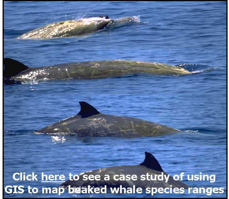
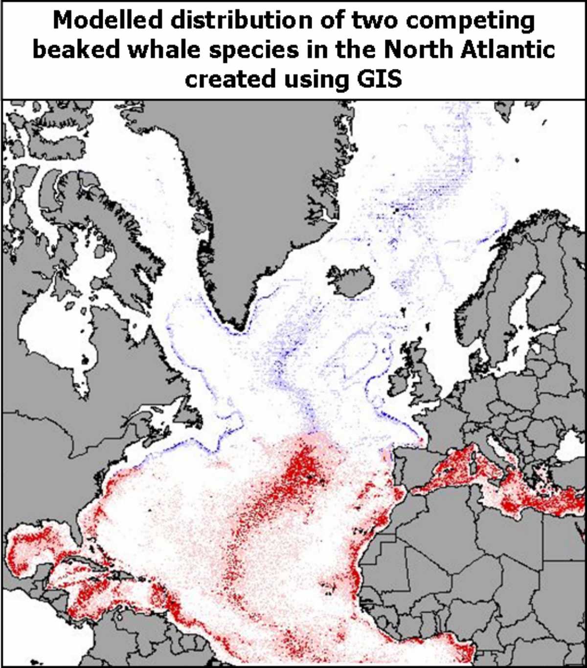
To use a motoring analogy, this is akin to teaching someone to drive by teaching them how the throttle and clutch of an internal combustion engine can be used to control the transfer of power to an axle and expecting them to be able to use this knowledge to be able to drive a variety of different vehicles. While this may give a firmer foundation to the knowledge of how driving is related to the functioning of the internal combustion engine, this is not the best approach for learning how to use driving as a practical skill in every day life. In terms of GIS, this KBL approach means that most training materials tend to describe what individual tools do or to describe individual concepts in GIS in a very generic form, and then rely on you to work out which ones you need to put together to do a specific task in your own area of interest. While you can learn GIS in this way, it requires you to learn an awful lot of stuff, some of which you will never actually need to know. This is not only very slow but can also be very confusing. It also leads to many people having great difficulty in seeing how GIS could be used in their own, every day activities, and therefore to give up on it before they even get started. For example, it can be very hard to see why being able to work out how to calculate the size of the human population in the catchment area for a store is even remotely relevant to ecological research. However, while you might never guess it until you know a lot about GIS, this is basically the same task as working out how many sightings of a particular species of whale, or other organism, occurred in each grid cell of a particular study area, something which is likely to be of more interest to an ecologist.
In the driving analogy used above, this is akin to teaching someone to drive a variety of different vehicles so that they can use them in their every day lives. Once they know how to drive several different vehicle types, it is much more likely that they can generalise this knowledge to work out how to drive an unfamiliar type of vehicle if they need to. If they wish, or if they later become sufficiently interested, they can also use this knowledge as the basis for exploring the wider generalities of how internal combustion engines work. If not, they can simply just keep driving around in whatever vehicle they might need to use without worrying too much about what exactly is happening under the bonnet.
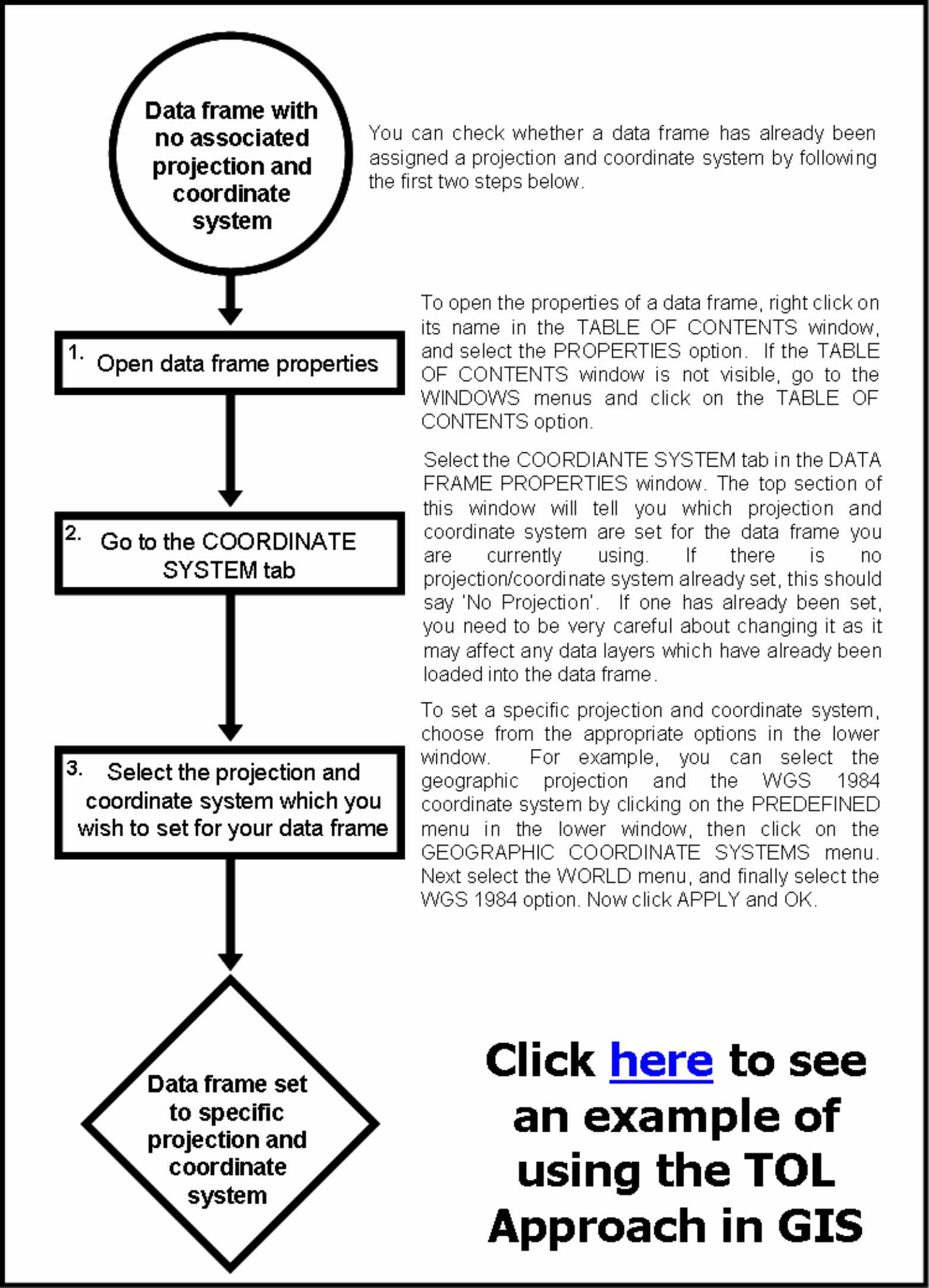
This not only reduces the risk that you will get lost and accidentally miss a specific instruction causing you to jump from midway through one step to another without completing it properly, it also means that you will find it easier to work out which instructions relate to specific key steps and, therefore, which blocks of instructions can be transferred as working units and combined with others similar blocks of instructions to create instruction sets for related, but unfamiliar, tasks. This nested hierarchical approach also allows you to combine entire instruction sets for individual tasks by adding an additional ‘summary’ flow diagram to identify which individual instruction sets need to be followed and in what order they need to be carried out in. As a result, you can use the basic building blocks taught as part of the TOL Approach to build up easy-to-follow instruction sets for what, at first, may seem like very complex tasks (click here to see an example of such a summary flow diagram taken from exercise one of An introduction To Using GIS In Marine Biology: Supplementary Workbook One By Colin D. MacLeod). More information on this approach to learning and teaching GIS can be found in An Introduction To Using GIS In Marine Biology By Colin D. MacLeod and An introduction To Using GIS In Marine Biology: Supplementary Workbook One By Colin D. MacLeod. |
|
|
GIS In Ecology Buttons For Your Website:
|
 Most
training courses in life sciences tend to focus on teaching practical skills
using a Knowledge-
Most
training courses in life sciences tend to focus on teaching practical skills
using a Knowledge-